Floaty McFloatface
Floaty McFloatface is a 200m depth rated seafloor imaging platform developed under EPSRC EP/S001182/1. It maintains a low altitude off the seafloor relying on underwater currents to drift along for lateral motion.
Key advantages of this approach are its low cost, long endurance (up to 10 days) and simplicity of operation, where only the surfacing time and depth limits need to be set by operators. It is equipped with an Iridium antenna to broadcast its location for recovery after its missions.
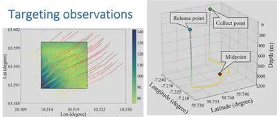
Our research develops methods to plan effective drift trajectories based on current predictions and the use of visual odometry combined with terrain matching for accurate georeferencing of the images Floaty obtains.
In the field
Floaty McFloatface has completed surveys of cold-water coral and seagrass since it was developed in 2021. Although the platform is not designed for metre precise targeting of seafloor geolocations, the ability to predict what regions it will observe is important both from an operational and scientific perspective.
The video below shows Floaty being deployed during Eurofleets Grassmap campaign.
Cruises
Eurofleets Grassmap 2021 - Monitoring of seagrass in the Balearic islands (PI Massot), see expedition page
EUMR Gunneras 2021 - Trondheim Fjord Cold water coral survey (PI Massot), see expedition page