BioCam develops 3D visual imaging technology for seafloor mapping applications (See article: Resolution and coverage, the best of both worlds.
Visualising and interpreting seafloor imagery on scales relevant for monitoring and planning
We have developed two BioCam systems, consisting of 4000m depth rated high resolution stereo camera system with dual LED strobes and dual laser s for seafloor 3d visual mapping. Developed as part of the NERC Oceanids programme together with Sonardyne International Ltd. The main camera unit dimensions are [LxBxH] 50x15x31.2cm, weighing 33kg. The system has been mounted on Autosub6000 and ALR6000 (a.k.a. Boaty Mcboatface) on multiple science and infrastructure inspection missions. Download specification.
The short range of most colour imaging systems typically requires underwater robots to carefully navigate underwater terrains at altitudes of just a few meters. BioCam leverage advanced in lighting and high-sensitivity detector technology, which allows colour imagery to be obtained from higher altitudes of up to 10 m, allowing faster-moving vehicles to be used and larger swaths of data to be collected. This allows sub-centimetre resolution 3D visual maps to be generated over multi-hectare region spatial scales that are relevant to many monitoring and infrastructure planning applications. The long-range 3D imaging technology was used by Team Kuroshio in the Shell Ocean Discovery Xprize, who won 2nd place in the grand final.
In addition to gathering data, BioCam also looks at scalable methods to reconstruct and interpret large volumes of seafloor imagery to generate insights on timescales relevent to oceanic expeditions. We work closely with the Australian Centre for Field Robotics, and several of our datasets are available on Squidle+. We are currently investigating methods to generate near-realtime remote awareness of data being captured in the ocean over the low communication bandwidths available in the open ocean.


Deployments of BioCam using Autosub6000 and BoatyMcBoatface.
And examples of some of the high-res bathymetry data gathered by ALR-BioCam during the OCEANIDS trial.
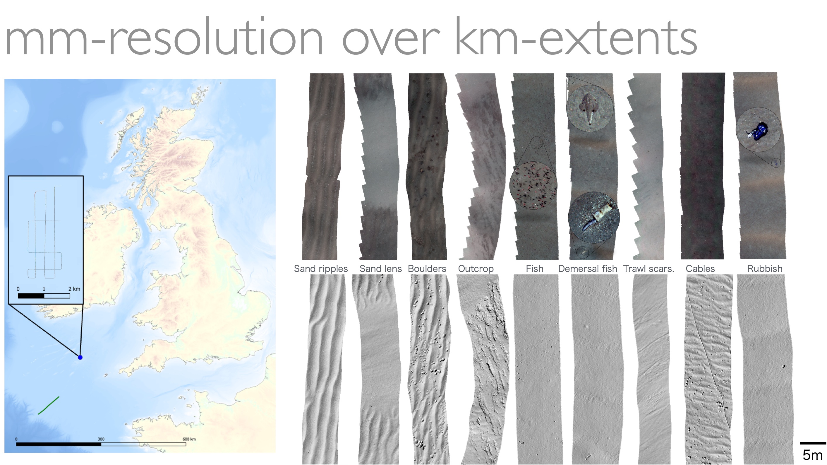
Examples of BioCam data from BoatyMcBoatface deployments in Haig Fras above, and below, observation of a decommissioned oil well during the AT-SEA 1000km, 20day ship-free shore launched trial (expedition page).

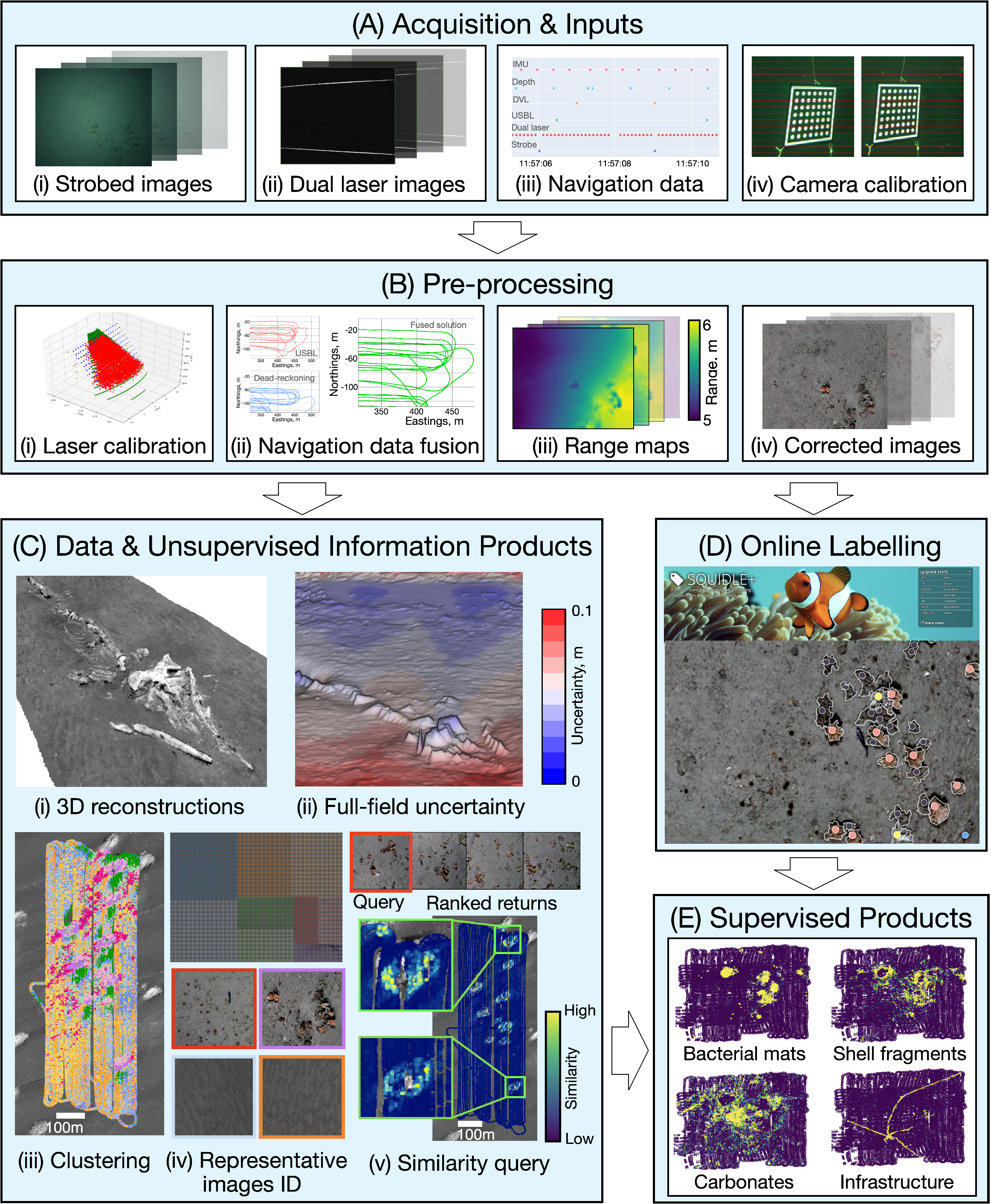
Overview of our processing pipeline.
Ocean Expeditions
- TechOceanS Plocan ALR-BioCam shore-launched missions for demonstrating remote awareness over ultra-low bandwidth satellite communication. See expedition page.
- DEFRA MPA Monitoring ALR-BioCam shore-launched missions for monitoing North Sea MPAs.
- INSTITE AT-SEA ALR-BioCam Shore-launched ship-free 21 day, 1013km traverse survey of NW Hutton and Miller decommissioned offshore oil and gas infrastructure. PI Jones (NOC). See expedition page.
- DY152 ALR-BioCam technical trials at Haig Fras and Southwest Deeps to demonstrate ship-free, over horizon mission retasking and image data quality control concepts. PI Phillips (NOC). See expedition page.
- DY108/109 Cold-Water-Coral mapping at Darwin Mounds using the AUV Autosub6000. PIs Thornton (UoS), Huveenne (NOC). See expedition page.
- SSK18-01 Coral mapping off Sesoko Island, Okinawa using the AUV TUNA-SAND. PIs Thornton (UoS), Harii (Uni. Ryukyus), Nishida (Kyutech). The survey took place 2 days after a direct strike from Typhoon Trami. See expedition page.
- FK180731 Adaptive Robotics at Barkley Canyon & Hydrate Ridge, off the R/V Falkor of the Schmidt Ocean Institute. Lead by Thornton (UoS). See expedition page.
- SSK17-01 Coral mapping off Sesoko Island, Okinawa using the AUV TUNA-SAND. PIs Thornton (UoS), Maki (UTokyo), Harii (Uni. Ryukyus) Pizarro (U, Sydney), Nishida (Kyutech). Supported by the Daiwa Foundation. See expedition page.
- Shell Ocean discovery XPrize Runner Up - Team Kuroshio.
Funding
This project is funded by NERC (NE/P020887/1) under the Oceanids Marine Sensor Capital program, 2017 to 2021. BioCam is part of the National Marine Facilities Technology Roadmap, and forms the basis for ship-free monitoring of offshore oil and gas infrastructure under AT-SEA (Autonomous Techniques for anthropogenic Structure Ecological Assessment, NE/T010592/1) as part of the NERC INSITE program from 2021 to 2024 where BioCam will be deployed from the National Oceanography Centre’s Boaty McBoaface. We are also part of the team delivering the EU H2020 TechOceanS (101000858) project from 2020 to 2024, which will develop sensing technologies for ship-free ocean sensing.